Leaders: Professor J. Stephen Daly and Dr Tom Belgrano
(University College Dublin)
21st August 2024, 7am departure from Trinity College Dublin (bus stop at Nassau Street)
Cost: €90 (inc. VAT of €16.83)
Participants should check their entitlement to visit Northern Ireland (UK). Some may require a visa.
Hammering and collecting of specimens is prohibited at all localities.
Easy walking but boots and outdoor clothing recommended.
The Giant’s Causeway is widely regarded as one of the geological wonders of World and as such has been has been the focus of scientific interest since the mid-Eighteenth century. The Causeway coast of Antrim provides excellent exposures of the Paleogene c. 63-60 m.y. old (Ganerød et al., 2010) Antrim Lava Group basalt lavas and the underlying Cretaceous Ulster White Limestone and Jurassic mudstone as well as a series of feeder intrusions in the form of abundant dolerite sills and dykes.
Together the Giant’s Causeway and the Causeway Coast are classified as a World Heritage Site (https://whc.unesco.org/en/list/) mainly because of the spectacular sea-level 3D exposures of columnar-jointed basalt. Historically, the first artistic images of the Giant’s Causeway influenced the Eighteenth-century debate on the origin of basalt favouring the Plutonists’ interpretation of an igneous origin that was supported by Nicholas Desmarest in France and James Hutton in Scotland and Revd William Hamilton in Ireland. The alternative Neptunist argument for a “water-lain” sedimentary origin for basalt was widely held at that time and was strongly supported by the field observations of Revd William Richardson. He identified abundant ammonite fossils in a dark-coloured rock that he mistakenly identified as basalt. Shortly afterwards, careful examination of specimens of the ammonite-bearing rock in Edinburgh by Sir James Hall settled the argument and we now understand that the Portrush locality (Stop 1 on this excursion) can be explained as a result of contact metamorphism of a Jurassic mudstone intruded by a similarly-coloured locally fine-grained dolerite intrusion.
We will visit three localities (Fig. 1) on this one-day excursion.
Please note that collecting and the use of hammers is prohibited at all of these localities.
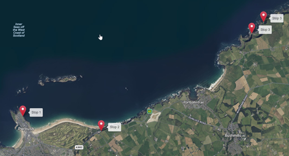
Stop 1. Portrush sill at Ramore Head, Portrush (55.210286°, -6.6553438°)
This is the place where Revd Richardson discovered ammonite fossils in the late eighteenth century in a rock that he interpreted as basalt. Because of its history (Wyse Jackson, 2006) and continuing importance for teaching and research (e.g., Ledevin et al., 2012; Shaw, 2019), this locality is classified as an Area of Special Scientific Interest (ASSI 113 – https://www.daera-ni.gov.uk/publications/ramore-head-skerries-assi).

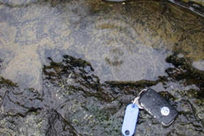
Fig. 2. (upper) General view of the Portrush sill; (lower) ammonites (Paltechyoceras) in contact-metamorphosed mudstone spuriously identified as basalt by Revd Richardson
At this locality we will examine the texture and mineralogy of the sill as well as the texture and composition of the Jurassic metasediments, particular their fossil content (Fig. 2) and field evidence for their original depositional nature. We will search for the boundary between the sill and the metasediments (Fig. 2) and carefully examine the contact between them. Some participants will find this a challenging test of their field geology skills!
Stop 2 Lava flows and a further perspective on the Portrush sill at Royal Court Hotel (55.205028°, -6058731°). Lunch stop.
Here we will examine part of the stratigraphy of the Antrim Lava Group, focusing on the contact between two lava flows (Fig. 2), which are exposed in the hotel carpark. The contact between these provides strong constraints on the environment of eruption. From the car park (weather permitting), we should be able to see the offshore extension of the Portrush sill (about 2km off to the NW)and its associated metasedimentary aureole exposed on a series of small islands as well as the evidence for the relative age of the basalt and the underlying Ulster White Limestone (Fig. 3).

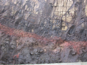
Fig. 3. (upper) Unconformable contact between the Antrim Lava Group and the underlying Cretaceous Ulster White Limestone; (lower) thin laterite horizon developed at the contact between two lavas, the upper of which displays vertical vesicle pipes.
Stop 3. Giant’s Causeway (55.240202°, -6.5109998°) and coastal path (55.244276°, -6.5035996°)
In addition to its status as a World Heritage Site, the Giants causeway is classified as an Area of Special Scientific Interest (ASSI 202 – https://www.daera-ni.gov.uk/publications/giants-causeway-and-dunseverick-assi).
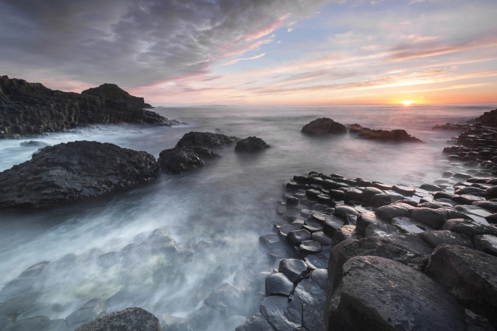
The Giant’s Causeway comprises c. 40,000 polygonal basalt columns (Fig. 4) that are exposed in 3D at and near sea level within one of the lava flows that form the Causeway Tholeiite Member of the Antrim Lava Group. The columns are generally near-vertical in orientation but many plunge at much gentler angles, presumably as a consequence of the orientation of the instantaneous cooling surface, which, in a relatively siliceous basaltic flow may be locally far from the horizontal.
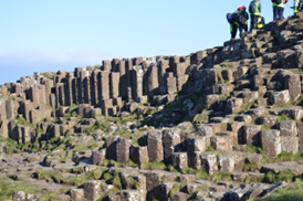
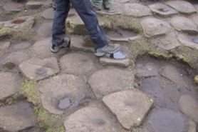
Fig. 4. Lateral and upper surface views of the polygonal columns that define the Giant’s Causeway. These basalt columns are developed within the Causeway Tholeiite Member.
Farther east, the Causeway Tholeiite Member occurs at a much higher elevation (Fig. 5) than at the Giant’s Causeway and the lower part of the lava stratigraphy is exposed (although only locally accessible) along the sea cliffs and coastal path. Controversy has arisen recently through the field observations of Simms (2021) who has re-interpreted the traditional explanations for the variable thicknesses of the columnar jointed flows and their different elevations. In particular he has questioned the idea (e.g. Tomkeieff, 1940) that the basalt flows had been locally thickened by flowing into a river valley which had eroded into the lower parts of the sequence. We will discuss these models and follow the coastal path to examine the lava stratigraphy as far as time allows. Along the path and at several other points we will also examine steeply-inclined (potentially feeder) dykes, at least one of which ascends to the cliff top demonstrating that it is younger than the youngest lava exposed here.
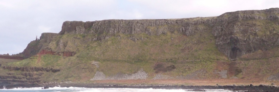
Fig. 5. Panoramic view eastwards from the Giant’s Causeway showing the Antrim Lava Group stratigraphy. The red laterite horizon (Port na Spaniagh Member) marks the top of the Lower Basalt Formation. This is overlain by several columnar jointed flows of the Causeway Tholeiite Member. including the tallest development of columns known as the Giant’s Organ.
References
Ganerød, M., Smethurst, M.A., Torsvik, T.H., Prestvik, T., Rousse, S., McKenna, C., van Hinsbergen, D.J.J., Hendriks, B.W.H. 2010. The North Atlantic Igneous Province reconstructed and its relation to the Plume Generation Zone: the Antrim Lava Group revisited. Geophysical Journal International, 182, 183–202. https://doi.org/10.1111/j.1365-246X.2010.04620.x
Ledevin, M., Arndt, N., Cooper, M.R., Earls, G., Lyle, P., Aubourg, C. and Lewin, E. 2012. Intrusion history of the Portrush Sill, County Antrim, Northern Ireland: evidence for rapid emplacement and high-temperature contact metamorphism. Geological Magazine, 149, 67-79. https://doi.org/10.1017/S0016756811000537
Simms, M. 2021. Subsidence, not erosion: Revisiting the emplacement environment of the Giant’s Causeway, Northern Ireland. Proceedings of the Geologists’ Association, 132, 537-548. https://doi.org/10.1016/j.pgeola.2021.07.001
Shaw, C.S.J. 2019. Metamorphic mineral assemblages in fossils in the contact metamorphic rocks of the Portrush Sill, Northern Ireland. Lithos, 338-339, 98-110. https://doi.org/10.1016/j.lithos.2019.04.016
Tomkeieff, S. L. 1940. The basalt lavas of the Giant’s Causeway district of northern Ireland. Bulletin of Volcanology, 6, 89-143. https://doi.org/10.1007/BF02994875
Wyse Jackson, P. 2006. The Chronologers’ Quest. Episodes in the Search for the Age of the Earth. Cambridge University Press, 291pp.