Cost: €85 (including VAT of €15.89).
Leaders: Dr Mike Stock, Jack Beckwith (Trinity College Dublin) and Dr Mark Cooper (Geological Survey of Northern Ireland)
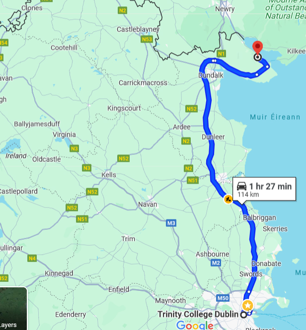
21st August 2024, 8.30 am departure from Trinity College Dublin (bus stop at Nassau Street).
Participants should check their entitlement to visit Northern Ireland (UK). Some may require a visa.
Hammering and collecting of specimens is prohibited at all localities.
Easy walking but boots and outdoor clothing recommended (participants should check the weather before departure and dress appropriately).
Palaeogene igneous intrusions in the British and Irish Igneous Province are some of the earliest expressions of the proto-Icelandic plume, with the largest and most geologically diverse examples exposed in Carlingford (Co. Louth) and Slieve Gullion Complex (Co. Armagh). These centres comprise compositionally bimodal, complex stratigraphies of gabbro and granite, alongside associated magma conduits (dykes and sills). The Slieve Gullion Igneous Centre includes a large and particularly well-preserved ring dyke structure which records the intrusion of magma along caldera collapse faults (the “Ring of Gullion”). Alongside their genetically- and temporally-related Scottish counterparts (e.g. Rum, Mull), the Irish Palaeogene intrusions played a central role in the development of early 20th Century igneous petrology and the development of seminal ideas which underpin our modern understanding of magmatic processes. They have also been subject to historic minerals exploration due to the high abundance of sulphides and chalcophile soil anomalies.
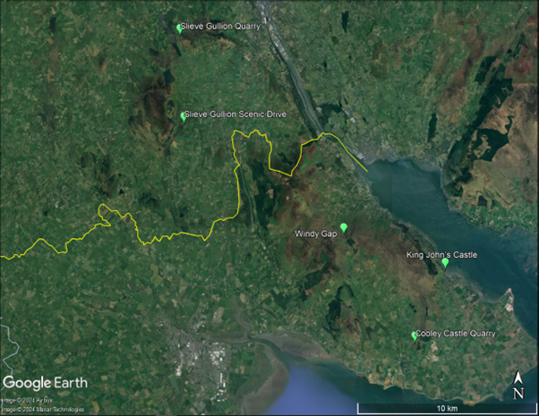
This trip will give an overview of the key lithologies and structures in the Calringford and Slieve Gullion Igneous Centres, visiting five accessible locations within a 1-1.5 hour drive from Dublin.
Stop 1. Windy Gap/Long Womans Grave (54.061002°, -6.273248°). This locality provides a good opportunity to observe the two main lithologies within the Carlingford Complex: layered gabbros and microgranites. While the gabbroic series does vary with stratigraphy, layers are mineralogically similar in hand specimen. Outcrops are on either side of a road and do not require any significant walking.
Stop 2. Cooley Castle Quarry (54.006896°, -6.213002°). Here, we will visit a small disused quarry which demonstrates the complex relationship between Carlingford felsic and mafic magmas. The outcrop is interpreted as showing back veining of granites by a later gabbroic intrusion, causing localised re-melting. A similar process was first recognised in outcrops of the Palaeogene Rum Intrusion in the Scottish Hebrides. The quarry wall is low and hard hats are not required but participants should be careful when approaching the rockface.
Stop 3. King John’s Castle (54.043523°, -6.187023°). Below the Medieval King Johns Castle on the side of Carlingford Lough is an excellent exposure of a cone sheet, which was intruded during emplacement of the Carlingford Complex. Like many Carlingford cone sheets, this locality shows evidence for strong flow segregation during magma migration, with particles (crystals) concentrated in the core of the dyke and relatively depleted at the margins. Reaching the outcrop requires descending a few uneven steps and walking a short distance along a rocky shoreline – participants must be wearing appropriate shoes.
After visiting the three Carlingford stops, the group will cross the boarder into Northern Ireland and stop for lunch at the Synge & Byrne café in the Slieve Gullion Forest Park.
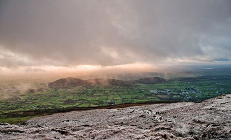
Stop 4. Slieve Gullion Scenic Drive (54.116441°, -6.409123°). A highlight of the fieldtrip is the Slieve Gullion Scenic drive, which allows for vehicle access to the summit of the Slieve Gullion mountain. Here, participants will enjoy excellent views across South Armagh and will get an excellent perspective on the ring dyke. During the drive, we will stop to see the mafic and felsic intrusive rocks exposed at Slieve Gullion, including examples of magma mingling.
Stop 5. Slieve Gullion Quarry (54.160420°, -6.412490°). After descending the mountain along the scenic drive, the group will stop at an active quarry, excavating the Slieve Gullion ring dyke. The provides an opportunity to look at the granophyric rocks which crystallised within the Ring of Gullion dyke during caldera collapse.
The coach will return participants to Trinity College Dublin (Nassau Street) and is expected to arrive back at approximately 18.00, depending on traffic.